


jour de pluie Fleurines

pierrol
User
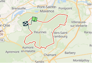

Length
32 km

Max alt
219 m

Uphill gradient
491 m
Km-Effort
38 km

Min alt
85 m

Downhill gradient
493 m
Boucle
No
Creation date :
2023-11-18 14:19:00.97
Updated on :
2023-11-18 14:33:07.432
2h38
Difficulty : Difficult

FREE GPS app for hiking
 SityTrail
IGN / Geographical institutes
SityTrail Plus
The world is yours!
About
Trail Mountain bike of 32 km to be discovered at Hauts-de-France, Oise, Verneuil-en-Halatte. This trail is proposed by pierrol.
Positioning
Country:
France
Region :
Hauts-de-France
Department/Province :
Oise
Municipality :
Verneuil-en-Halatte
Location:
Unknown
Start:(Dec)
Start:(UTM)
468125 ; 5457851 (31U) N.
Comments