Coux le ouzin

raygautier
User

Length
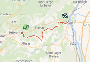
18.3 km

Max alt
432 m

Uphill gradient
605 m
Km-Effort
27 km

Min alt
88 m

Downhill gradient
711 m
Boucle
No
Creation date :
2023-11-19 09:07:47.0
Updated on :
2023-11-19 15:47:43.585

FREE GPS app for hiking
 SityTrail
IGN / Geographical institutes
SityTrail Plus
The world is yours!
About
Trail of 18.3 km to be discovered at Auvergne-Rhône-Alpes, Ardèche, Coux. This trail is proposed by raygautier.
Positioning
Country:
France
Region :
Auvergne-Rhône-Alpes
Department/Province :
Ardèche
Municipality :
Coux
Location:
Unknown
Start:(Dec)
Start:(UTM)
628556 ; 4954860 (31T) N.
Comments