


faron. 21 Nov 2023

tessonnierg
User
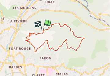

Length
10.5 km

Max alt
529 m

Uphill gradient
420 m
Km-Effort
16.1 km

Min alt
190 m

Downhill gradient
422 m
Boucle
Yes
Creation date :
2023-11-21 08:37:26.663
Updated on :
2023-12-08 15:27:22.966
3h39
Difficulty : Difficult

FREE GPS app for hiking
 SityTrail
IGN / Geographical institutes
SityTrail Plus
The world is yours!
About
Trail Walking of 10.5 km to be discovered at Provence-Alpes-Côte d'Azur, Var, Toulon. This trail is proposed by tessonnierg.
Description
2 étoiles
Positioning
Country:
France
Region :
Provence-Alpes-Côte d'Azur
Department/Province :
Var
Municipality :
Toulon
Location:
Unknown
Start:(Dec)
Start:(UTM)
738268 ; 4781740 (31T) N.
Comments