


Feins étang du boulet 8km

coglais
User
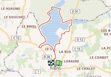

Length
8.2 km

Max alt
101 m

Uphill gradient
85 m
Km-Effort
9.4 km

Min alt
67 m

Downhill gradient
85 m
Boucle
Yes
Creation date :
2023-11-21 18:37:22.508
Updated on :
2023-11-21 18:39:30.893
2h00
Difficulty : Very easy

FREE GPS app for hiking
 SityTrail
IGN / Geographical institutes
SityTrail Plus
The world is yours!
About
Trail Nordic walking of 8.2 km to be discovered at Brittany, Ille-et-Vilaine, Feins. This trail is proposed by coglais.
Positioning
Country:
France
Region :
Brittany
Department/Province :
Ille-et-Vilaine
Municipality :
Feins
Location:
Unknown
Start:(Dec)
Start:(UTM)
600666 ; 5353686 (30U) N.
Comments