


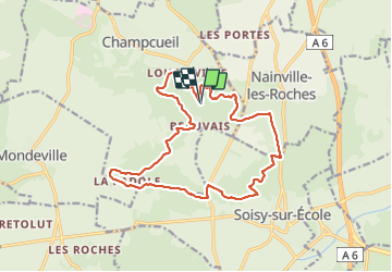
R1-Beauvais-Champcueil

Jack-94
User

Length
16.6 km

Max alt
147 m

Uphill gradient
276 m
Km-Effort
20 km

Min alt
81 m

Downhill gradient
276 m
Boucle
Yes
Creation date :
2023-11-21 21:47:21.018
Updated on :
2023-11-25 22:24:21.422
4h37
Difficulty : Very difficult

FREE GPS app for hiking
 SityTrail
IGN / Geographical institutes
SityTrail Plus
The world is yours!
About
Trail Walking of 16.6 km to be discovered at Ile-de-France, Essonne, Champcueil. This trail is proposed by Jack-94.
Positioning
Country:
France
Region :
Ile-de-France
Department/Province :
Essonne
Municipality :
Champcueil
Location:
Unknown
Start:(Dec)
Start:(UTM)
460794 ; 5372208 (31U) N.
Comments