


Amicale_Ancy_12

d.rognon
User
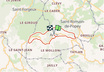

Length
12.1 km

Max alt
734 m

Uphill gradient
401 m
Km-Effort
17.4 km

Min alt
435 m

Downhill gradient
402 m
Boucle
Yes
Creation date :
2023-11-23 08:57:19.681
Updated on :
2024-10-08 09:12:20.283
3h57
Difficulty : Difficult

FREE GPS app for hiking
 SityTrail
IGN / Geographical institutes
SityTrail Plus
The world is yours!
About
Trail Walking of 12.1 km to be discovered at Auvergne-Rhône-Alpes, Rhône, Ancy. This trail is proposed by d.rognon.
Description
Sentier des croix autour de Ancy
Randonnée réalisée le 19/3/24
Positioning
Country:
France
Region :
Auvergne-Rhône-Alpes
Department/Province :
Rhône
Municipality :
Ancy
Location:
Unknown
Start:(Dec)
Start:(UTM)
617201 ; 5077159 (31T) N.
Comments