Chaligny nov 23

Nila81
User
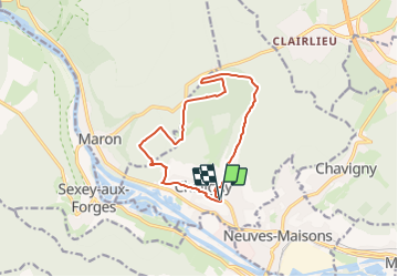

Length
11.6 km

Max alt
417 m

Uphill gradient
279 m
Km-Effort
15.3 km

Min alt
238 m

Downhill gradient
280 m
Boucle
Yes
Creation date :
2023-11-23 09:25:22.496
Updated on :
2023-11-23 09:26:05.496
3h28
Difficulty : Difficult

FREE GPS app for hiking
 SityTrail
IGN / Geographical institutes
SityTrail Plus
The world is yours!
About
Trail Walking of 11.6 km to be discovered at Grand Est, Meurthe-et-Moselle, Chaligny. This trail is proposed by Nila81.
Positioning
Country:
France
Region :
Grand Est
Department/Province :
Meurthe-et-Moselle
Municipality :
Chaligny
Location:
Unknown
Start:(Dec)
Start:(UTM)
285243 ; 5389632 (32U) N.
Comments