


Allan 9km

thonyc
User GUIDE
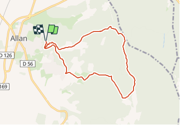

Length
8.5 km

Max alt
403 m

Uphill gradient
252 m
Km-Effort
11.9 km

Min alt
204 m

Downhill gradient
253 m
Boucle
Yes
Creation date :
2023-11-24 09:46:56.406
Updated on :
2023-11-24 09:49:05.327
2h30
Difficulty : Easy

FREE GPS app for hiking
 SityTrail
IGN / Geographical institutes
SityTrail Plus
The world is yours!
About
Trail Walking of 8.5 km to be discovered at Auvergne-Rhône-Alpes, Drôme, Allan. This trail is proposed by thonyc.
Positioning
Country:
France
Region :
Auvergne-Rhône-Alpes
Department/Province :
Drôme
Municipality :
Allan
Location:
Unknown
Start:(Dec)
Start:(UTM)
642787 ; 4928852 (31T) N.
Comments