


Arbonne / Coquibus

mimimartine
User
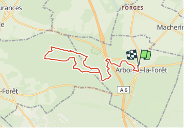

Length
17.6 km

Max alt
137 m

Uphill gradient
199 m
Km-Effort
20 km

Min alt
70 m

Downhill gradient
199 m
Boucle
Yes
Creation date :
2023-11-24 17:46:45.051
Updated on :
2023-11-24 17:47:44.675
4h35
Difficulty : Medium

FREE GPS app for hiking
 SityTrail
IGN / Geographical institutes
SityTrail Plus
The world is yours!
About
Trail On foot of 17.6 km to be discovered at Ile-de-France, Seine-et-Marne, Arbonne-la-Forêt. This trail is proposed by mimimartine.
Positioning
Country:
France
Region :
Ile-de-France
Department/Province :
Seine-et-Marne
Municipality :
Arbonne-la-Forêt
Location:
Unknown
Start:(Dec)
Start:(UTM)
467816 ; 5362405 (31U) N.
Comments