


balade jean mi

terrano
User
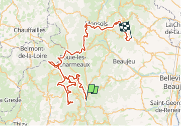

Length
81 km

Max alt
925 m

Uphill gradient
2961 m
Km-Effort
119 km

Min alt
405 m

Downhill gradient
2630 m
Boucle
No
Creation date :
2023-11-25 08:32:49.277
Updated on :
2023-11-25 16:31:31.696
7h56
Difficulty : Very easy

FREE GPS app for hiking
 SityTrail
IGN / Geographical institutes
SityTrail Plus
The world is yours!
About
Trail 4x4 of 81 km to be discovered at Auvergne-Rhône-Alpes, Rhône, Claveisolles. This trail is proposed by terrano.
Positioning
Country:
France
Region :
Auvergne-Rhône-Alpes
Department/Province :
Rhône
Municipality :
Claveisolles
Location:
Unknown
Start:(Dec)
Start:(UTM)
615437 ; 5103348 (31T) N.
Comments