


GR10 Barèges - lac Oredon

winkelmuller
User
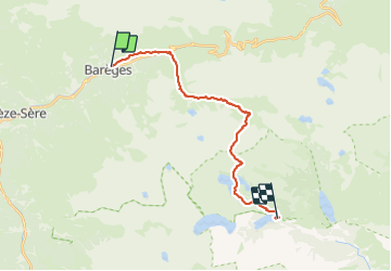

Length
21 km

Max alt
2506 m

Uphill gradient
1422 m
Km-Effort
38 km

Min alt
1232 m

Downhill gradient
745 m
Boucle
No
Creation date :
2023-06-15 05:59:31.164
Updated on :
2023-11-26 07:01:59.274
13h06
Difficulty : Very difficult

FREE GPS app for hiking
 SityTrail
IGN / Geographical institutes
SityTrail Plus
The world is yours!
About
Trail Walking of 21 km to be discovered at Occitania, Hautespyrenees, Barèges. This trail is proposed by winkelmuller.
Positioning
Country:
France
Region :
Occitania
Department/Province :
Hautespyrenees
Municipality :
Barèges
Location:
Unknown
Start:(Dec)
Start:(UTM)
260359 ; 4753527 (31T) N.
Comments