


Fringuet

raygautier
User
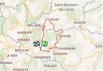

Length
12.6 km

Max alt
642 m

Uphill gradient
387 m
Km-Effort
17.7 km

Min alt
457 m

Downhill gradient
388 m
Boucle
Yes
Creation date :
2023-11-26 07:57:37.0
Updated on :
2023-11-26 11:10:38.129

FREE GPS app for hiking
 SityTrail
IGN / Geographical institutes
SityTrail Plus
The world is yours!
About
Trail of 12.6 km to be discovered at Auvergne-Rhône-Alpes, Ardèche, Champis. This trail is proposed by raygautier.
Positioning
Country:
France
Region :
Auvergne-Rhône-Alpes
Department/Province :
Ardèche
Municipality :
Champis
Location:
Unknown
Start:(Dec)
Start:(UTM)
639341 ; 4978009 (31T) N.
Comments