Trail  Bouxières-aux-Dames - Maron les baraques retour villey VillersvVilleyeone  - Photo

Maron les baraques retour villey VillersvVilleyeone

© OpenStreetMap contributors
Length
Length
55 km
Max alt
Max alt
390 m
Uphill gradient
Uphill gradient
702 m
Km-Effort
Km-Effort  
64 km
Min alt
Min alt
188 m
Downhill gradient
Downhill gradient
696 m
Boucle
Boucle
No
Creation date :
2023-11-26 08:40:44.0
Updated on :
2023-11-26 12:42:54.343

(0 Reviews)


Scan this QR Code to open this trail in the SityTrail application

FREE GPS app for hiking

Logo SityTrail SityTrail

IGN / Geographical institutes

Download SityTrail from the App Store Download SityTrail from Google Play

Logo SityTrail SityTrail Plus

The world is yours!

Download SityTrail from the App Store Download SityTrail from Google Play Download SityTrail on Huawei AppGallery

About

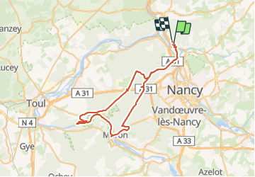
Trail of 55 km to be discovered at Grand Est, Meurthe-et-Moselle, Bouxières-aux-Dames. This trail is proposed by lorenzot54.

Description

Champigneulles val de Bellefontaine, les baraques, Maron voie verte jusqu’à l’écluse de Villers, montée sur Villey direction Maron puis chemin forestier à gauche jusqu’à zone de loisirs route forestière goudronnée jusqu’à l’étang de Bellefontaine

Elevation profile

Positioning

Country:
France
Region :
Grand Est
Department/Province :
Meurthe-et-Moselle
Municipality :
Bouxières-aux-Dames
Location:
Unknown
Start:(UTM)
291417 ; 5403829 (32U) N.


Close
My subscriptions