


Rando Ethe

Ratel
User
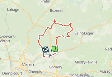

Length
26 km

Max alt
373 m

Uphill gradient
470 m
Km-Effort
32 km

Min alt
211 m

Downhill gradient
482 m
Boucle
Yes
Creation date :
2023-11-26 08:10:27.0
Updated on :
2023-11-26 15:48:34.572
7h28
Difficulty : Difficult

FREE GPS app for hiking
 SityTrail
IGN / Geographical institutes
SityTrail Plus
The world is yours!
About
Trail Walking of 26 km to be discovered at Wallonia, Luxembourg, Virton. This trail is proposed by Ratel.
Positioning
Country:
Belgium
Region :
Wallonia
Department/Province :
Luxembourg
Municipality :
Virton
Location:
Unknown
Start:(Dec)
Start:(UTM)
686718 ; 5495193 (31U) N.
Comments