


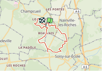
A53-JG-Beauvais-Champcueil

Jack-94
User

Length
14.9 km

Max alt
144 m

Uphill gradient
227 m
Km-Effort
17.9 km

Min alt
82 m

Downhill gradient
238 m
Boucle
Yes
Creation date :
2023-11-26 08:34:22.12
Updated on :
2023-11-26 16:04:29.06
5h56
Difficulty : Difficult

FREE GPS app for hiking
 SityTrail
IGN / Geographical institutes
SityTrail Plus
The world is yours!
About
Trail Walking of 14.9 km to be discovered at Ile-de-France, Essonne, Champcueil. This trail is proposed by Jack-94.
Positioning
Country:
France
Region :
Ile-de-France
Department/Province :
Essonne
Municipality :
Champcueil
Location:
Unknown
Start:(Dec)
Start:(UTM)
460769 ; 5372270 (31U) N.
Comments