


cruet

papou73
User
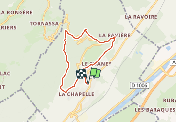

Length
6.9 km

Max alt
636 m

Uphill gradient
330 m
Km-Effort
11.3 km

Min alt
349 m

Downhill gradient
329 m
Boucle
Yes
Creation date :
2023-11-27 12:17:31.795
Updated on :
2023-11-27 14:41:28.738
2h09
Difficulty : Medium

FREE GPS app for hiking
 SityTrail
IGN / Geographical institutes
SityTrail Plus
The world is yours!
About
Trail Walking of 6.9 km to be discovered at Auvergne-Rhône-Alpes, Savoy, Cruet. This trail is proposed by papou73.
Positioning
Country:
France
Region :
Auvergne-Rhône-Alpes
Department/Province :
Savoy
Municipality :
Cruet
Location:
Unknown
Start:(Dec)
Start:(UTM)
272954 ; 5045466 (32T) N.
Comments