


ludres la cantine 12kms

ZAMBAUX
User
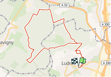

Length
11.9 km

Max alt
422 m

Uphill gradient
227 m
Km-Effort
15 km

Min alt
268 m

Downhill gradient
227 m
Boucle
Yes
Creation date :
2023-11-28 13:44:48.046
Updated on :
2023-12-09 16:51:40.804
3h24
Difficulty : Difficult

FREE GPS app for hiking
 SityTrail
IGN / Geographical institutes
SityTrail Plus
The world is yours!
About
Trail Walking of 11.9 km to be discovered at Grand Est, Meurthe-et-Moselle, Ludres. This trail is proposed by ZAMBAUX.
Positioning
Country:
France
Region :
Grand Est
Department/Province :
Meurthe-et-Moselle
Municipality :
Ludres
Location:
Unknown
Start:(Dec)
Start:(UTM)
291184 ; 5389103 (32U) N.
Comments