


Sarras

raygautier
User
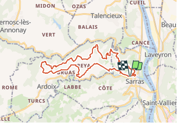

Length
18.9 km

Max alt
381 m

Uphill gradient
655 m
Km-Effort
28 km

Min alt
127 m

Downhill gradient
657 m
Boucle
Yes
Creation date :
2023-12-03 08:17:00.0
Updated on :
2023-12-03 14:31:50.149

FREE GPS app for hiking
 SityTrail
IGN / Geographical institutes
SityTrail Plus
The world is yours!
About
Trail of 18.9 km to be discovered at Auvergne-Rhône-Alpes, Ardèche, Sarras. This trail is proposed by raygautier.
Positioning
Country:
France
Region :
Auvergne-Rhône-Alpes
Department/Province :
Ardèche
Municipality :
Sarras
Location:
Unknown
Start:(Dec)
Start:(UTM)
641020 ; 5005789 (31T) N.
Comments
merci