


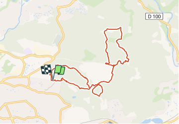
SAINT RAPHAEL CRAPA / FERRIERES / CAOUS

Michel DUBOIS
User

Length
10.6 km

Max alt
171 m

Uphill gradient
318 m
Km-Effort
14.8 km

Min alt
53 m

Downhill gradient
317 m
Boucle
Yes
Creation date :
2023-12-03 15:29:40.6
Updated on :
2023-12-03 15:32:09.528
3h22
Difficulty : Medium

FREE GPS app for hiking
 SityTrail
IGN / Geographical institutes
SityTrail Plus
The world is yours!
About
Trail Walking of 10.6 km to be discovered at Provence-Alpes-Côte d'Azur, Var, Saint-Raphaël. This trail is proposed by Michel DUBOIS.
Positioning
Country:
France
Region :
Provence-Alpes-Côte d'Azur
Department/Province :
Var
Municipality :
Saint-Raphaël
Location:
Unknown
Start:(Dec)
Start:(UTM)
322715 ; 4810782 (32T) N.
Comments
belle marche, superbe paysage !