


2023-12-06 Rando Cerny

jchezlemas
User
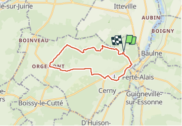

Length
12 km

Max alt
155 m

Uphill gradient
158 m
Km-Effort
14.1 km

Min alt
53 m

Downhill gradient
158 m
Boucle
Yes
Creation date :
2023-12-06 08:11:41.27
Updated on :
2023-12-06 17:23:01.388
2h56
Difficulty : Easy

FREE GPS app for hiking
 SityTrail
IGN / Geographical institutes
SityTrail Plus
The world is yours!
About
Trail Walking of 12 km to be discovered at Ile-de-France, Essonne, Cerny. This trail is proposed by jchezlemas.
Positioning
Country:
France
Region :
Ile-de-France
Department/Province :
Essonne
Municipality :
Cerny
Location:
Unknown
Start:(Dec)
Start:(UTM)
451322 ; 5371428 (31U) N.
Comments