


Caire col de bruisse vallon de maigre pic de Naouri caire

franquen
User
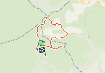

Length
8.1 km

Max alt
1037 m

Uphill gradient
402 m
Km-Effort
13.9 km

Min alt
759 m

Downhill gradient
537 m
Boucle
No
Creation date :
2023-12-06 10:39:10.801
Updated on :
2023-12-06 13:41:39.329
3h02
Difficulty : Difficult

FREE GPS app for hiking
 SityTrail
IGN / Geographical institutes
SityTrail Plus
The world is yours!
About
Trail Walking of 8.1 km to be discovered at Provence-Alpes-Côte d'Azur, Maritime Alps, Tourrettes-sur-Loup. This trail is proposed by franquen.
Positioning
Country:
France
Region :
Provence-Alpes-Côte d'Azur
Department/Province :
Maritime Alps
Municipality :
Tourrettes-sur-Loup
Location:
Unknown
Start:(Dec)
Start:(UTM)
342966 ; 4844501 (32T) N.
Comments