


Rando Fontainebleau 19km

jeanmarcMasson
User GUIDE
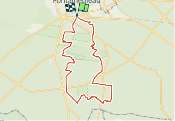

Length
18.7 km

Max alt
140 m

Uphill gradient
291 m
Km-Effort
23 km

Min alt
77 m

Downhill gradient
291 m
Boucle
Yes
Creation date :
2023-12-06 08:58:56.213
Updated on :
2023-12-06 15:00:05.391
4h35
Difficulty : Very difficult

FREE GPS app for hiking
 SityTrail
IGN / Geographical institutes
SityTrail Plus
The world is yours!
About
Trail Walking of 18.7 km to be discovered at Ile-de-France, Seine-et-Marne, Fontainebleau. This trail is proposed by jeanmarcMasson.
Positioning
Country:
France
Region :
Ile-de-France
Department/Province :
Seine-et-Marne
Municipality :
Fontainebleau
Location:
Unknown
Start:(Dec)
Start:(UTM)
477945 ; 5360414 (31U) N.
Comments