


le moulin de corbierre

CANON2
User
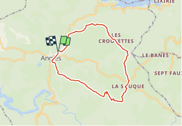

Length
15.1 km

Max alt
871 m

Uphill gradient
401 m
Km-Effort
20 km

Min alt
728 m

Downhill gradient
402 m
Boucle
Yes
Creation date :
2023-12-07 09:08:38.251
Updated on :
2023-12-07 09:09:08.244
4h38
Difficulty : Medium

FREE GPS app for hiking
 SityTrail
IGN / Geographical institutes
SityTrail Plus
The world is yours!
About
Trail On foot of 15.1 km to be discovered at Occitania, Tarn, Anglès. This trail is proposed by CANON2.
Positioning
Country:
France
Region :
Occitania
Department/Province :
Tarn
Municipality :
Anglès
Location:
Unknown
Start:(Dec)
Start:(UTM)
464934 ; 4823875 (31T) N.
Comments