


Theize Bois d'Oingt

Jean-Marc C
User
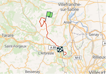

Length
30 km

Max alt
584 m

Uphill gradient
558 m
Km-Effort
38 km

Min alt
200 m

Downhill gradient
688 m
Boucle
No
Creation date :
2023-12-07 07:53:36.714
Updated on :
2023-12-07 11:54:38.002
4h00
Difficulty : Very difficult

FREE GPS app for hiking
 SityTrail
IGN / Geographical institutes
SityTrail Plus
The world is yours!
About
Trail Walking of 30 km to be discovered at Auvergne-Rhône-Alpes, Rhône, Theizé. This trail is proposed by Jean-Marc C.
Positioning
Country:
France
Region :
Auvergne-Rhône-Alpes
Department/Province :
Rhône
Municipality :
Theizé
Location:
Unknown
Start:(Dec)
Start:(UTM)
625104 ; 5088622 (31T) N.
Comments