


rando Valenton - Lac Creteil 20km

jeanmarcMasson
User GUIDE
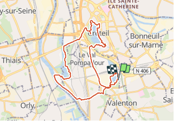

Length
19.7 km

Max alt
64 m

Uphill gradient
153 m
Km-Effort
22 km

Min alt
25 m

Downhill gradient
150 m
Boucle
Yes
Creation date :
2023-12-13 08:29:01.204
Updated on :
2024-11-29 09:42:48.409
4h56
Difficulty : Very difficult

FREE GPS app for hiking
 SityTrail
IGN / Geographical institutes
SityTrail Plus
The world is yours!
About
Trail Walking of 19.7 km to be discovered at Ile-de-France, Val-de-Marne, Valenton. This trail is proposed by jeanmarcMasson.
Positioning
Country:
France
Region :
Ile-de-France
Department/Province :
Val-de-Marne
Municipality :
Valenton
Location:
Unknown
Start:(Dec)
Start:(UTM)
460845 ; 5400420 (31U) N.
Comments