


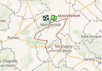
Montjavoult la grange aux Nonains

serge.guerroult
User

Length
11.5 km

Max alt
202 m

Uphill gradient
175 m
Km-Effort
13.9 km

Min alt
88 m

Downhill gradient
177 m
Boucle
Yes
Creation date :
2023-12-13 15:38:05.584
Updated on :
2023-12-14 13:29:39.917
3h09
Difficulty : Easy

FREE GPS app for hiking
 SityTrail
IGN / Geographical institutes
SityTrail Plus
The world is yours!
About
Trail On foot of 11.5 km to be discovered at Hauts-de-France, Oise, Montjavoult. This trail is proposed by serge.guerroult.
Positioning
Country:
France
Region :
Hauts-de-France
Department/Province :
Oise
Municipality :
Montjavoult
Location:
Unknown
Start:(Dec)
Start:(UTM)
411428 ; 5451998 (31U) N.
Comments