


Fleury la Forêt le Grand Val

serge.guerroult
User
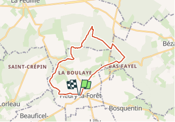

Length
13.1 km

Max alt
196 m

Uphill gradient
158 m
Km-Effort
15.2 km

Min alt
129 m

Downhill gradient
157 m
Boucle
Yes
Creation date :
2023-12-03 08:17:20.192
Updated on :
2023-12-14 19:04:22.957
3h26
Difficulty : Difficult

FREE GPS app for hiking
 SityTrail
IGN / Geographical institutes
SityTrail Plus
The world is yours!
About
Trail Walking of 13.1 km to be discovered at Normandy, Eure, Fleury-la-Forêt. This trail is proposed by serge.guerroult.
Positioning
Country:
France
Region :
Normandy
Department/Province :
Eure
Municipality :
Fleury-la-Forêt
Location:
Unknown
Start:(Dec)
Start:(UTM)
395135 ; 5475094 (31U) N.
Comments