Trail Horseback riding Flines-lez-Raches - Tracé Equirencontre 2024 - Photo

Tracé Equirencontre 2024

© OpenStreetMap contributors
Length
Length
70 km
Max alt
Max alt
75 m
Uphill gradient
Uphill gradient
454 m
Km-Effort
Km-Effort  
76 km
Min alt
Min alt
12 m
Downhill gradient
Downhill gradient
457 m
Boucle
Boucle
No
Creation date :
2023-12-14 15:23:00.96
Updated on :
2024-03-19 13:16:39.226

(0 Reviews)

Horseback riding
Horseback riding
9h57
Difficulty : Very difficult

Scan this QR Code to open this trail in the SityTrail application

FREE GPS app for hiking

Logo SityTrail SityTrail

IGN / Geographical institutes

Download SityTrail from the App Store Download SityTrail from Google Play

Logo SityTrail SityTrail World

The world is yours!

Download SityTrail from the App Store Download SityTrail from Google Play Download SityTrail on Huawei AppGallery

About

Trail Horseback riding of 70 km to be discovered at Hauts-de-France, Nord, Flines-lez-Raches. This trail is proposed by Hélène Lallez.

Elevation profile

Points of interest

Point of interest Tilloy-lez-Marchiennes - Etape 1 - Photo
Hélène Lallez
TILLOY-LEZ-MARCHIENNES 
Point of interest Marchiennes - repas etape 1 - Photo
Hélène Lallez
MARCHIENNES 

Positioning

Country:
France
Region :
Hauts-de-France
Department/Province :
Nord
Municipality :
Flines-lez-Raches
Location:
Unknown
Start:(UTM)
513037 ; 5585442 (31U) N.

Trails nearby

Trail Walking Coutiches - Circuit des chapelles de Coutiches.    - Photo
Walking
tracegps

Walking

Difficult
(1)
Coutiches, Hauts-de-France, Nord, France
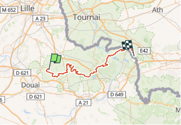
15.2 km | 16.3 km-effort
3h 34min
Yes
Trail Mountain bike Lallaing - lallaing - la fosse delloye - Photo
Mountain bike
patrick59

Mountain bike

Medium
(1)
Lallaing, Hauts-de-France, Nord, France
26 km | 29 km-effort
1h 41min
No
Trail Mountain bike Lallaing - 2012-08-17 lallaing 3 cavaliers - Photo
Mountain bike
patrick59

Mountain bike

Medium
(1)
Lallaing, Hauts-de-France, Nord, France
44 km | 47 km-effort
2h 50min
No
Trail Mountain bike Lallaing - lallaing - circuit de l'elpret - Photo
Mountain bike
patrick59

Mountain bike

Medium
(1)
Lallaing, Hauts-de-France, Nord, France
40 km | 43 km-effort
2h 56min
Yes
Trail Mountain bike Anhiers - lallaing - Mons en peveles - Photo
Mountain bike
patrick59

Mountain bike

Easy
(1)
Anhiers, Hauts-de-France, Nord, France
27 km | 29 km-effort
1h 32min
No
Trail Mountain bike Anhiers - rando renard - Photo
Mountain bike
patrick59

Mountain bike

Very easy
(1)
Anhiers, Hauts-de-France, Nord, France
20 km | 22 km-effort
1h 17min
No
Trail Mountain bike Flines-lez-Raches - La rando VTT des Renards des Sables - Flines les Raches - Photo
Mountain bike
tracegps

Mountain bike

Difficult
Flines-lez-Raches, Hauts-de-France, Nord, France
47 km | 52 km-effort
3h 0min
No
Trail Walking Vred - Circuit de Germignies - Vred - Photo
Walking
tracegps

Walking

Medium
(1)
Vred, Hauts-de-France, Nord, France
7.6 km | 8.2 km-effort
2h 0min
Yes
Trail Walking Anhiers - Circuit des 2 ponts - Anhiers - Photo
Walking
tracegps

Walking

Easy
Anhiers, Hauts-de-France, Nord, France
7.1 km | 7.4 km-effort
1h 49min
Yes


Close
My subscriptions