


theize oingt

Jean-Marc C
User
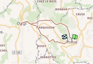

Length
7.4 km

Max alt
585 m

Uphill gradient
210 m
Km-Effort
10.2 km

Min alt
419 m

Downhill gradient
214 m
Boucle
Yes
Creation date :
2023-12-14 14:32:18.635
Updated on :
2023-12-14 16:31:45.862
1h55
Difficulty : Medium

FREE GPS app for hiking
 SityTrail
IGN / Geographical institutes
SityTrail Plus
The world is yours!
About
Trail Walking of 7.4 km to be discovered at Auvergne-Rhône-Alpes, Rhône, Theizé. This trail is proposed by Jean-Marc C.
Positioning
Country:
France
Region :
Auvergne-Rhône-Alpes
Department/Province :
Rhône
Municipality :
Theizé
Location:
Unknown
Start:(Dec)
Start:(UTM)
625273 ; 5088626 (31T) N.
Comments