


sente des lapins

dedejojo
User

Length
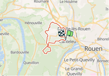
19.8 km

Max alt
150 m

Uphill gradient
270 m
Km-Effort
23 km

Min alt
54 m

Downhill gradient
269 m
Boucle
Yes
Creation date :
2023-12-15 06:49:07.228
Updated on :
2023-12-15 06:49:59.944
5h18
Difficulty : Very difficult

FREE GPS app for hiking
 SityTrail
IGN / Geographical institutes
SityTrail Plus
The world is yours!
About
Trail Walking of 19.8 km to be discovered at Normandy, Seine-Maritime, Canteleu. This trail is proposed by dedejojo.
Positioning
Country:
France
Region :
Normandy
Department/Province :
Seine-Maritime
Municipality :
Canteleu
Location:
Unknown
Start:(Dec)
Start:(UTM)
357289 ; 5479616 (31U) N.
Comments