


st jeannet,baou de la gaude,retour par château bresson

franquen
User
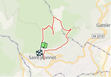

Length
6.9 km

Max alt
835 m

Uphill gradient
333 m
Km-Effort
11.7 km

Min alt
404 m

Downhill gradient
437 m
Boucle
No
Creation date :
2023-12-16 11:19:11.809
Updated on :
2023-12-16 14:25:03.791
3h05
Difficulty : Medium

FREE GPS app for hiking
 SityTrail
IGN / Geographical institutes
SityTrail Plus
The world is yours!
About
Trail Walking of 6.9 km to be discovered at Provence-Alpes-Côte d'Azur, Maritime Alps, Saint-Jeannet. This trail is proposed by franquen.
Positioning
Country:
France
Region :
Provence-Alpes-Côte d'Azur
Department/Province :
Maritime Alps
Municipality :
Saint-Jeannet
Location:
Unknown
Start:(Dec)
Start:(UTM)
350366 ; 4845772 (32T) N.
Comments