COUDRAY 20 KM

UDGI54
User
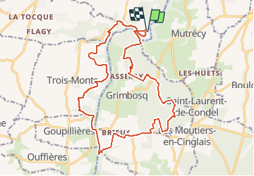

Length
19.8 km

Max alt
146 m

Uphill gradient
419 m
Km-Effort
25 km

Min alt
14 m

Downhill gradient
416 m
Boucle
Yes
Creation date :
2018-03-13 00:00:00.0
Updated on :
2018-03-13 00:00:00.0
5h26
Difficulty : Difficult

FREE GPS app for hiking
 SityTrail
IGN / Geographical institutes
SityTrail Plus
The world is yours!
About
Trail Walking of 19.8 km to be discovered at Normandy, Calvados, Maizet. This trail is proposed by UDGI54.
Positioning
Country:
France
Region :
Normandy
Department/Province :
Calvados
Municipality :
Maizet
Location:
Unknown
Start:(Dec)
Start:(UTM)
686929 ; 5437796 (30U) N.
Comments