


STJDBOIS

UDGI54
User
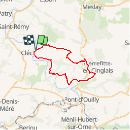

Length
19.7 km

Max alt
271 m

Uphill gradient
600 m
Km-Effort
28 km

Min alt
38 m

Downhill gradient
595 m
Boucle
Yes
Creation date :
2015-02-23 00:00:00.0
Updated on :
2015-02-23 00:00:00.0
--
Difficulty : Difficult

FREE GPS app for hiking
 SityTrail
IGN / Geographical institutes
SityTrail Plus
The world is yours!
About
Trail Walking of 19.7 km to be discovered at Normandy, Calvados, Le Vey. This trail is proposed by UDGI54.
Positioning
Country:
France
Region :
Normandy
Department/Province :
Calvados
Municipality :
Le Vey
Location:
Unknown
Start:(Dec)
Start:(UTM)
685212 ; 5421329 (30U) N.
Comments