


Honneck, lac blanchemer

lorenzot54
User
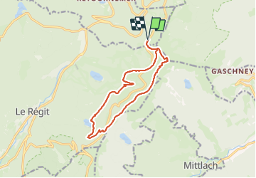

Length
12.7 km

Max alt
1350 m

Uphill gradient
463 m
Km-Effort
18.9 km

Min alt
991 m

Downhill gradient
468 m
Boucle
Yes
Creation date :
2023-12-16 09:26:40.0
Updated on :
2023-12-16 18:41:04.366

FREE GPS app for hiking
 SityTrail
IGN / Geographical institutes
SityTrail Plus
The world is yours!
About
Trail of 12.7 km to be discovered at Grand Est, Vosges, Xonrupt-Longemer. This trail is proposed by lorenzot54.
Positioning
Country:
France
Region :
Grand Est
Department/Province :
Vosges
Municipality :
Xonrupt-Longemer
Location:
Unknown
Start:(Dec)
Start:(UTM)
351378 ; 5323125 (32U) N.
Comments