


Boucle vers le Bois français - 17 déc 23

morganee
User
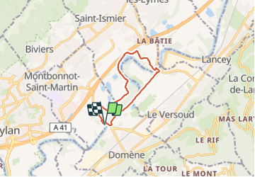

Length
10.1 km

Max alt
237 m

Uphill gradient
85 m
Km-Effort
11.2 km

Min alt
215 m

Downhill gradient
84 m
Boucle
Yes
Creation date :
2023-12-17 13:17:36.092
Updated on :
2023-12-17 15:35:56.251
2h17
Difficulty : Very easy

FREE GPS app for hiking
 SityTrail
IGN / Geographical institutes
SityTrail Plus
The world is yours!
About
Trail Walking of 10.1 km to be discovered at Auvergne-Rhône-Alpes, Isère, Montbonnot-Saint-Martin. This trail is proposed by morganee.
Positioning
Country:
France
Region :
Auvergne-Rhône-Alpes
Department/Province :
Isère
Municipality :
Montbonnot-Saint-Martin
Location:
Unknown
Start:(Dec)
Start:(UTM)
722124 ; 5010347 (31T) N.
Comments