


Chamarandes 18/12/23

janussity
User

Length
5.7 km

Max alt
358 m

Uphill gradient
102 m
Km-Effort
7 km

Min alt
258 m

Downhill gradient
103 m
Boucle
Yes
Creation date :
2023-12-18 12:25:11.595
Updated on :
2023-12-18 12:26:30.8
1h35
Difficulty : Medium

FREE GPS app for hiking
 SityTrail
IGN / Geographical institutes
SityTrail Plus
The world is yours!
About
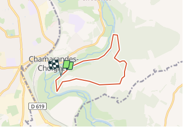
Trail Walking of 5.7 km to be discovered at Grand Est, Haute-Marne, Chamarandes-Choignes. This trail is proposed by janussity.
Description
Rando douce
Positioning
Country:
France
Region :
Grand Est
Department/Province :
Haute-Marne
Municipality :
Chamarandes-Choignes
Location:
Unknown
Start:(Dec)
Start:(UTM)
660765 ; 5328549 (31U) N.
Comments