


BOISMONT 2023-12-21

patdecosnes
User
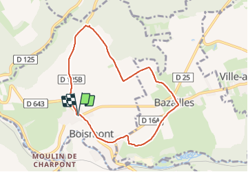

Length
7.2 km

Max alt
344 m

Uphill gradient
83 m
Km-Effort
8.3 km

Min alt
283 m

Downhill gradient
82 m
Boucle
Yes
Creation date :
2023-12-21 12:25:22.0
Updated on :
2023-12-26 22:29:17.529
1h42
Difficulty : Medium

FREE GPS app for hiking
 SityTrail
IGN / Geographical institutes
SityTrail Plus
The world is yours!
About
Trail Walking of 7.2 km to be discovered at Grand Est, Meurthe-et-Moselle, Boismont. This trail is proposed by patdecosnes.
Description
temps de merde
Positioning
Country:
France
Region :
Grand Est
Department/Province :
Meurthe-et-Moselle
Municipality :
Boismont
Location:
Unknown
Start:(Dec)
Start:(UTM)
698694 ; 5476196 (31U) N.
Comments