


Mont Brouilly de St Lager

janussity
User
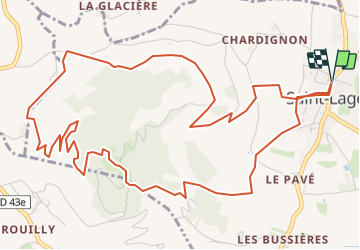

Length
7.6 km

Max alt
482 m

Uphill gradient
337 m
Km-Effort
12 km

Min alt
240 m

Downhill gradient
336 m
Boucle
Yes
Creation date :
2023-12-22 17:17:35.244
Updated on :
2023-12-22 17:20:53.802
2h44
Difficulty : Difficult

FREE GPS app for hiking
 SityTrail
IGN / Geographical institutes
SityTrail Plus
The world is yours!
About
Trail Walking of 7.6 km to be discovered at Auvergne-Rhône-Alpes, Rhône, Saint-Lager. This trail is proposed by janussity.
Description
A reconnaitre
Positioning
Country:
France
Region :
Auvergne-Rhône-Alpes
Department/Province :
Rhône
Municipality :
Saint-Lager
Location:
Unknown
Start:(Dec)
Start:(UTM)
629271 ; 5107939 (31T) N.
Comments