


dorli-rosh-ottrott-obernai

Titinechris
User
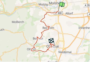

Length
26 km

Max alt
320 m

Uphill gradient
409 m
Km-Effort
32 km

Min alt
175 m

Downhill gradient
399 m
Boucle
No
Creation date :
2023-12-26 17:09:43.225
Updated on :
2023-12-26 17:10:45.128
0m
Difficulty : Easy

FREE GPS app for hiking
 SityTrail
IGN / Geographical institutes
SityTrail Plus
The world is yours!
About
Trail Running of 26 km to be discovered at Grand Est, Bas-Rhin, Dorlisheim. This trail is proposed by Titinechris.
Positioning
Country:
France
Region :
Grand Est
Department/Province :
Bas-Rhin
Municipality :
Dorlisheim
Location:
Unknown
Start:(Dec)
Start:(UTM)
389125 ; 5376200 (32U) N.
Comments