


Les 3 becs

raygautier
User
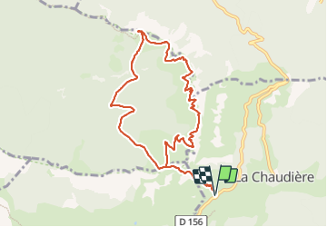

Length
10.7 km

Max alt
1565 m

Uphill gradient
825 m
Km-Effort
22 km

Min alt
1032 m

Downhill gradient
831 m
Boucle
Yes
Creation date :
2023-12-27 07:41:26.0
Updated on :
2023-12-27 13:44:55.38

FREE GPS app for hiking
 SityTrail
IGN / Geographical institutes
SityTrail Plus
The world is yours!
About
Trail of 10.7 km to be discovered at Auvergne-Rhône-Alpes, Drôme, La Chaudière. This trail is proposed by raygautier.
Positioning
Country:
France
Region :
Auvergne-Rhône-Alpes
Department/Province :
Drôme
Municipality :
La Chaudière
Location:
Unknown
Start:(Dec)
Start:(UTM)
674878 ; 4944185 (31T) N.
Comments