


Boucle arrière de l'Isère - 27 déc 23

morganee
User
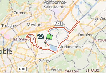

Length
16.9 km

Max alt
228 m

Uphill gradient
136 m
Km-Effort
18.7 km

Min alt
208 m

Downhill gradient
134 m
Boucle
Yes
Creation date :
2023-12-27 13:20:24.268
Updated on :
2023-12-27 16:55:38.669
3h34
Difficulty : Easy

FREE GPS app for hiking
 SityTrail
IGN / Geographical institutes
SityTrail Plus
The world is yours!
About
Trail Walking of 16.9 km to be discovered at Auvergne-Rhône-Alpes, Isère, Meylan. This trail is proposed by morganee.
Positioning
Country:
France
Region :
Auvergne-Rhône-Alpes
Department/Province :
Isère
Municipality :
Meylan
Location:
Unknown
Start:(Dec)
Start:(UTM)
719297 ; 5008291 (31T) N.
Comments