


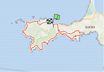
Presqu'ile de Giens

FSantoni
User

Length
11.4 km

Max alt
95 m

Uphill gradient
391 m
Km-Effort
16.5 km

Min alt
0 m

Downhill gradient
371 m
Boucle
No
Creation date :
2023-12-28 08:50:27.571
Updated on :
2023-12-28 17:11:45.938
5h33
Difficulty : Difficult

FREE GPS app for hiking
 SityTrail
IGN / Geographical institutes
SityTrail Plus
The world is yours!
About
Trail Walking of 11.4 km to be discovered at Provence-Alpes-Côte d'Azur, Var, Hyères. This trail is proposed by FSantoni.
Description
Les paysages magnifiques se succédent.
Tout comme les montées et les descentes !
Photos


Positioning
Country:
France
Region :
Provence-Alpes-Côte d'Azur
Department/Province :
Var
Municipality :
Hyères
Location:
Unknown
Start:(Dec)
Start:(UTM)
264567 ; 4769290 (32T) N.
Comments