


Montée vers le plateau de la Limatte en partant de Signes

FSantoni
User
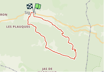

Length
17.3 km

Max alt
734 m

Uphill gradient
490 m
Km-Effort
24 km

Min alt
317 m

Downhill gradient
492 m
Boucle
Yes
Creation date :
2023-12-30 07:52:28.023
Updated on :
2023-12-30 17:00:21.541
6h19
Difficulty : Very difficult

FREE GPS app for hiking
 SityTrail
IGN / Geographical institutes
SityTrail Plus
The world is yours!
About
Trail Walking of 17.3 km to be discovered at Provence-Alpes-Côte d'Azur, Var, Signes. This trail is proposed by FSantoni.
Description
Très belle randonnée pour cette dernière de 2023 !
Photos


Positioning
Country:
France
Region :
Provence-Alpes-Côte d'Azur
Department/Province :
Var
Municipality :
Signes
Location:
Unknown
Start:(Dec)
Start:(UTM)
732681 ; 4797090 (31T) N.
Comments