


Annecy

sergelopez
User
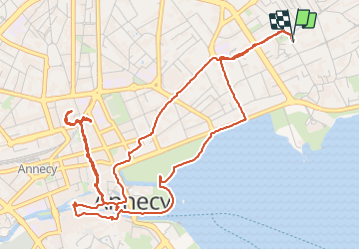

Length
7.4 km

Max alt
464 m

Uphill gradient
68 m
Km-Effort
8.3 km

Min alt
447 m

Downhill gradient
67 m
Boucle
Yes
Creation date :
2023-12-16 14:58:23.863
Updated on :
2024-01-02 21:20:37.954
2h40
Difficulty : Medium

FREE GPS app for hiking
 SityTrail
IGN / Geographical institutes
SityTrail Plus
The world is yours!
About
Trail Walking of 7.4 km to be discovered at Auvergne-Rhône-Alpes, Upper Savoy, Annecy. This trail is proposed by sergelopez.
Positioning
Country:
France
Region :
Auvergne-Rhône-Alpes
Department/Province :
Upper Savoy
Municipality :
Annecy
Location:
Annecy-le-Vieux
Start:(Dec)
Start:(UTM)
278391 ; 5087885 (32T) N.
Comments