


plateau pierre d'appel

Titinechris
User
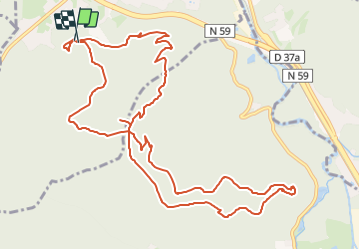

Length
13.6 km

Max alt
596 m

Uphill gradient
483 m
Km-Effort
20 km

Min alt
352 m

Downhill gradient
477 m
Boucle
Yes
Creation date :
2024-01-06 20:47:07.671
Updated on :
2024-01-06 20:47:41.027
0m
Difficulty : Easy

FREE GPS app for hiking
 SityTrail
IGN / Geographical institutes
SityTrail Plus
The world is yours!
About
Trail Trail of 13.6 km to be discovered at Grand Est, Vosges, Raon-l'Étape. This trail is proposed by Titinechris.
Positioning
Country:
France
Region :
Grand Est
Department/Province :
Vosges
Municipality :
Raon-l'Étape
Location:
Unknown
Start:(Dec)
Start:(UTM)
339035 ; 5362336 (32U) N.
Comments