


le crestet Vaison la Romaine

losjo
User
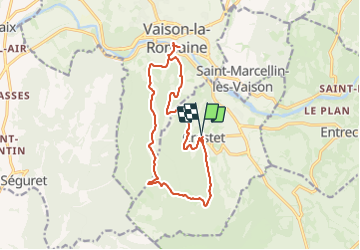

Length
16 km

Max alt
502 m

Uphill gradient
389 m
Km-Effort
21 km

Min alt
207 m

Downhill gradient
392 m
Boucle
Yes
Creation date :
2024-01-07 21:43:42.132
Updated on :
2024-01-07 21:45:13.285
4h49
Difficulty : Medium

FREE GPS app for hiking
 SityTrail
IGN / Geographical institutes
SityTrail Plus
The world is yours!
About
Trail On foot of 16 km to be discovered at Provence-Alpes-Côte d'Azur, Vaucluse, Crestet. This trail is proposed by losjo.
Positioning
Country:
France
Region :
Provence-Alpes-Côte d'Azur
Department/Province :
Vaucluse
Municipality :
Crestet
Location:
Unknown
Start:(Dec)
Start:(UTM)
666492 ; 4898063 (31T) N.
Comments