


Bagnols

Jean-Marie J
User
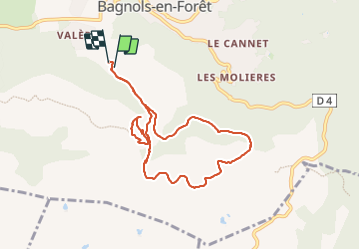

Length
8.6 km

Max alt
419 m

Uphill gradient
262 m
Km-Effort
12.1 km

Min alt
248 m

Downhill gradient
260 m
Boucle
Yes
Creation date :
2024-01-10 09:04:59.349
Updated on :
2024-01-10 13:36:44.469
2h33
Difficulty : Difficult

FREE GPS app for hiking
 SityTrail
IGN / Geographical institutes
SityTrail Plus
The world is yours!
About
Trail Walking of 8.6 km to be discovered at Provence-Alpes-Côte d'Azur, Var, Bagnols-en-Forêt. This trail is proposed by Jean-Marie J.
Positioning
Country:
France
Region :
Provence-Alpes-Côte d'Azur
Department/Province :
Var
Municipality :
Bagnols-en-Forêt
Location:
Unknown
Start:(Dec)
Start:(UTM)
313439 ; 4822257 (32T) N.
Comments