


di

brandy
User
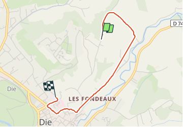

Length
2.9 km

Max alt
506 m

Uphill gradient
16 m
Km-Effort
3.4 km

Min alt
418 m

Downhill gradient
97 m
Boucle
No
Creation date :
2024-01-13 14:48:17.836
Updated on :
2024-01-13 15:33:33.41
30m
Difficulty : Easy

FREE GPS app for hiking
 SityTrail
IGN / Geographical institutes
SityTrail Plus
The world is yours!
About
Trail Walking of 2.9 km to be discovered at Auvergne-Rhône-Alpes, Drôme, Die. This trail is proposed by brandy.
Positioning
Country:
France
Region :
Auvergne-Rhône-Alpes
Department/Province :
Drôme
Municipality :
Die
Location:
Unknown
Start:(Dec)
Start:(UTM)
688228 ; 4959413 (31T) N.
Comments