


pont des Tuves montauroux

Jean Raynal
User
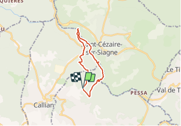

Length
10.7 km

Max alt
431 m

Uphill gradient
340 m
Km-Effort
15.2 km

Min alt
164 m

Downhill gradient
339 m
Boucle
Yes
Creation date :
2024-01-15 07:43:39.965
Updated on :
2024-01-15 10:45:39.884
3h01
Difficulty : Medium

FREE GPS app for hiking
 SityTrail
IGN / Geographical institutes
SityTrail Plus
The world is yours!
About
Trail Walking of 10.7 km to be discovered at Provence-Alpes-Côte d'Azur, Var, Montauroux. This trail is proposed by Jean Raynal.
Positioning
Country:
France
Region :
Provence-Alpes-Côte d'Azur
Department/Province :
Var
Municipality :
Montauroux
Location:
Unknown
Start:(Dec)
Start:(UTM)
320903 ; 4833256 (32T) N.
Comments