


Boucle Yerres Brunoy Epinay 12km

jeanmarcMasson
User GUIDE
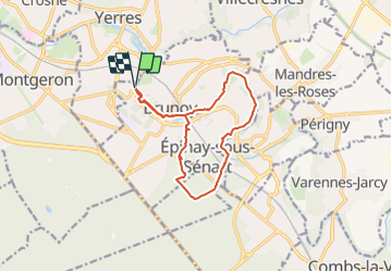

Length
12 km

Max alt
96 m

Uphill gradient
117 m
Km-Effort
13.6 km

Min alt
38 m

Downhill gradient
117 m
Boucle
Yes
Creation date :
2024-01-15 12:55:44.0
Updated on :
2024-01-21 21:05:37.103
3h04
Difficulty : Difficult

FREE GPS app for hiking
 SityTrail
IGN / Geographical institutes
SityTrail Plus
The world is yours!
About
Trail Walking of 12 km to be discovered at Ile-de-France, Essonne, Brunoy. This trail is proposed by jeanmarcMasson.
Description
Départ Parking piscine de Yerres
Positioning
Country:
France
Region :
Ile-de-France
Department/Province :
Essonne
Municipality :
Brunoy
Location:
Unknown
Start:(Dec)
Start:(UTM)
462754 ; 5394442 (31U) N.
Comments